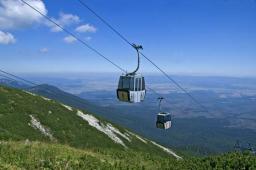
Map - climb
On the map of the High Tatras, on a scale of 1:11000, are cable car stations in the Tatranska Lomnica and the Skalnate Pleso with a distance of 354.6 mm. The altitude of these stations is 949 m and 1760 m.
What is the average angle of climb on this cable car track?
Your answer:
What is the average angle of climb on this cable car track?
Your answer:
Tips for related online calculators
See also our right triangle calculator.
See also our trigonometric triangle calculator.
Try conversion angle units angle degrees, minutes, seconds, radians, grads.
See also our trigonometric triangle calculator.
Try conversion angle units angle degrees, minutes, seconds, radians, grads.
You need to know the following knowledge to solve this word math problem:
planimetrygoniometry and trigonometryUnits of physical quantitiesthemes, topicsGrade of the word problem
We encourage you to watch this tutorial video on this math problem: video1
Related math problems and questions:
- Atmospheric pressure
 How and by how much hPa will the atmospheric pressure change when we take the cable car from Skalnate Pleso to Lomnický štít? The altitudes of the cable car stations are 1754 m above sea level and 2634 m above sea level.
 - Cable car climb
 The lower station of the cable car in Smokovec is at an altitude of 1025 m, and the upper station at Hrebienk is at an altitude of 1272 m. Calculate the climb of the cable car if the horizontal distance between the slopes is 1921 m.
 - Cable car
 A cable car rises at an angle of 44° and connects the upper and lower stations with an altitude difference of 1089 m. How long is the continuous (endless) tow rope?
 - Map actual distance
 On a tourist map with a scale of 1:50 000, the distance between Štrbské Pleso and Štrba is 14 cm. What is the actual distance?
 - The cable car
 The cable car is 3,5 kilometers long and climbs at a 30 degrees angle. What is the altitude difference between the Upper and Lower stations?
 - Tourist group meeting
 From Tatranská Lomnica to Ždiar, 40 km apart, two groups of tourists went opposite each other. Pedestrians left Tatranská Lomnica at 9:00 AM at an average speed of 4 km/h. Cyclists from Ždiar at 9:30 at an average speed of 15 km/h. When will they meet? At
 - Cable car 2
 The cable car rises at an angle of 16° and connects the upper and lower station with an altitude difference of 1082 m. How long is the cable car's track?
